Rainfall warnings issued, freeze and icy conditions to follow
Rainfall Warnings have been issued for Kings and Queens counties in Prince Edward Island. The warning calls for 25 to 35 mm of rain Friday evening through Saturday noon.
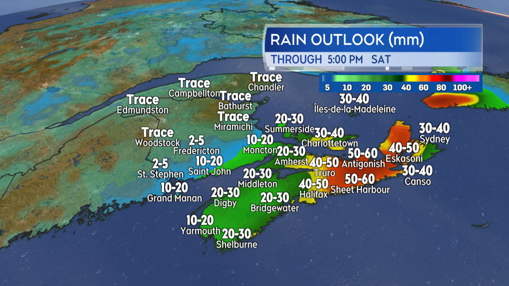
Much of Nova Scotia is also under a Rainfall Warning. For that province, areas under the warning can expect 25 to 50 mm of rain with high local amounts Friday evening through Saturday evening. Special Weather Statements in effect for Kings, Queens, and Shelburne counties call for slightly lower amounts of up to 25 mm of rain. No warning or statement in effect for Yarmouth, Digby, and Annapolis counties.
In the warnings and statements, Environment Canada cautions that “significant snowmelt and runoff may occur” and that “similar storms in the past have caused pooling of water on roadways and localized flooding in low lying areas.”
If you can, clearing accessible drainage from snow and ice could help with the runoff expected.
A heavy winter rain is expected for parts of Nova Scotia and Prince Edward Island. Melting snow and ice along with blocked drainage increasing the risk of localized flooding.
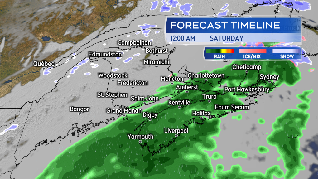
Rain and snowFriday afternoon and early evening will see a light mix of snow and rain for the Maritimes. There is a risk of some patchy, light freezing rain.
The heavier rain arrives late Friday evening into Saturday morning.
Heavier rain is expected to arrive for southern New Brunswick, Nova Scotia, and Prince Edward Island late evening and near midnight, the heavier rain continuing into Saturday morning. The rain turns to a mix of freezing rain and snow Saturday before clearing west-to-east through the day.
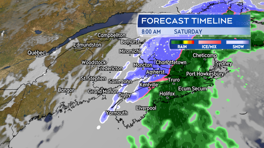
Rain clears west-to-east through Saturday. Some areas turning over to a mix of snow, ice pellets and freezing rain.
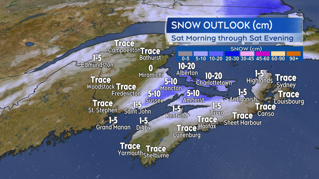
Southeastern New Brunswick, northern Nova Scotia, and Prince Edward Island look like they could get into some particularly slick conditions Saturday morning into afternoon. Indications are that area of the Maritimes could switch from the rain over to 5 to 15 cm of snow, ice pellets and freezing rain.
The flip back to a snowy, icy mix of precipitation could lead to some accumulations of 5 to 15 cm for parts of the Maritimes on Saturday.
Freeze and risk of iceIt won’t just be those areas that switch from rain to snow and freezing rain that will need to be cautious of icy surfaces this weekend. A cold front follows the mix of precipitation as it clears. Living up to the name, that front will put the region over into a cold, gusty northwest wind. Temperatures are expected to come down back below freezing in as little as 2 to 6 hours following the change in wind direction.
Wet or slushy surfaces could turn icy quickly. That would include roads, sidewalks, and parking lots.
New Brunswick will be below freezing by early Saturday afternoon. Prince Edward Island below freezing by late Saturday afternoon. Nova Scotia below freezing by and through Saturday evening.
I’ll have updates, timelines and regional weather conditions on CTV New Atlantic programming Friday 5 p.m., 6 p.m., and 11:30 p.m.


