Tornado watch issued for Ottawa Valley, parts of Quebec; Thunderstorm watch for Ottawa
Severe weather moving across eastern Ontario has triggered several alerts, including some tornado warnings.
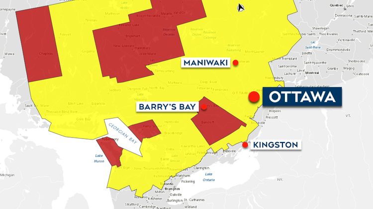
A tornado watch has been issued by Environment Canada for the Ottawa Valley and some parts Quebec, while Ottawa is under a severe thunderstorm watch.
The statement was issued Thursday. Impacted areas under tornado watches are Petawawa, Pembroke, Cobden, Smiths Falls, Perth, Lanark County, Plevna, Sharbot Lake, Renfrew, Arnprior, Calabogie, Barry's Bay and Killaloe.
Just after 5 p.m. a tornado warning was issued for the Kaladar, Bannockburn and Bon Echo Park area, north of Napanee. It ended just after 6 p.m. but a tornado watch remained in effect.
A tornado warning was issued for the Plevna, Sharbot Lake and western Lanark County area at around 5:45 p.m. Environment Canada said meteorologists are tracking a severe thunderstorm that is possibly producing a tornado.
A severe thunderstorm warning was in effect for the Killaloe and Barry's Bay area but has since ended. A tornado watch remains in effect.
Tornado watches are in effect in parts of Quebec including Upper Gatineau, Lievre, Mont Laurier, Abitibi, Papineau, Parent, Temiscamingue and Guin Reservoir. There are tornado warnings in effect in the Val d'Or – Louvicourt areas and the Ville-Marie area of Quebec.
A risk of tornado, strong wind gusts of up to 110 kilometres per hour, large hail of up to 4 centimetres and heavy downpours giving 50 millimetres of rain are among the main threats included in the tornado watch.
"Conditions are favourable for the development of severe thunderstorms capable of producing tornadoes late this afternoon and this evening," said the weather agency in its statement. "Be prepared for severe weather. Take cover immediately, if threatening weather approaches."
In Ottawa, the severe thunderstorm watch was issued just before 4:45 p.m., warning residents of thunderstorms that are expected to develop and track through the region this evening, which could bring wind gusts of up to 90 km/h, nickel- to toonie-sized hail and the risk of a tornado.


