Tornado warning issued for Cambridge area, severe thunderstorm ...
Posted August 17, 2024 11:16 am.
Last Updated August 17, 2024 12:11 pm.
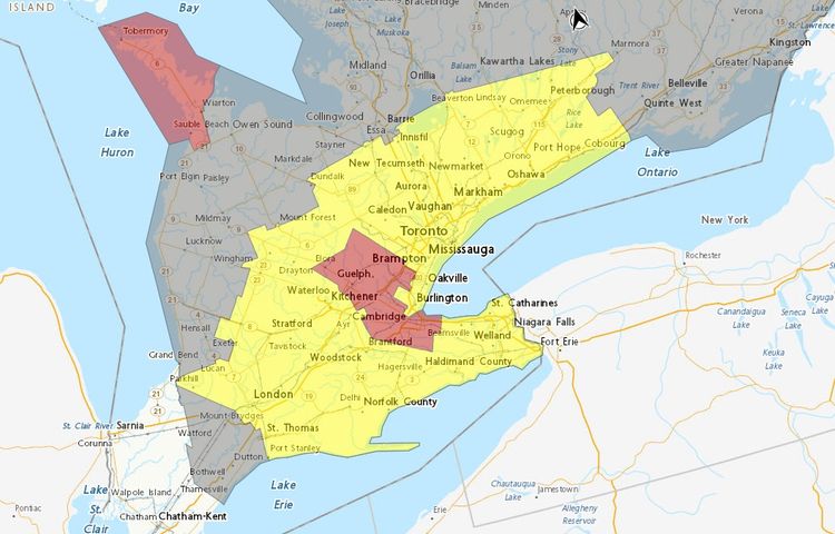
Environment and Climate Change Canada forecasters have issued several severe thunderstorm warnings and watches across parts of southern Ontario while authorities near Kitchener-Waterloo respond to reports of damage potentially caused by a tornado.
Meteorologists issued a tornado warning for Cambridge, Roseville, Breslau, Preston, Hespeler, West Guelph, Aberfoyle and Morriston just after 11 a.m. At the time, they said they were tracking a severe thunderstorm that could produce a tornado.
“Damaging winds, large hail and locally intense rainfall are also possible,” the warning said, noting there were wind gusts of 90 km/h.
“A severe thunderstorm capable of producing a tornado is located near Roseville, moving northeast at 40 km/h.”
However, by 11:30 a.m., that warning was dropped in favour of a severe thunderstorm warning.
Waterloo Regional Police officers said in a post on X that moments after the tornado warning was dropped they received calls from residents advising a tornado touched down in Ayr, which is roughly 17 kilometres west of downtown Cambridge.
Officers said part of Greenfield Drive in Ayr was closed after trees and hydro poles were knocked down. They also said a roof at the local Home Hardware was damaged and North Dumfries Fire Department crews were responding to the building to deal with reports natural gas was detected.
A post on the Township of North Dumfries X account shared a photo from Jake Nagle, which appeared to show a tornado.
There were no immediate reports of injuries.
Forecasters said the storm is moving east at around 30 km/h and can produce strong wind, nickel-sized hail and heavy rain.
“Heavy downpours can cause flash floods and water pooling on roads. Large hail can damage property and cause injury. Strong wind gusts can toss loose objects, damage weak buildings, break branches off trees and overturn large vehicles,” they said.
“Remember, severe thunderstorms can produce tornadoes.”
Meanwhile, a severe thunderstorm watch issued for most of the Greater Toronto Area said conditions were “favourable for the development of severe thunderstorms that may be capable of producing strong wind gusts, large hail and heavy rain.” The watch said thunderstorms could bring rainfall rates of 40 millimetres.
It’s expected the weather will clear Saturday evening.
Click here to access the latest weather warnings and watches from Environment and Climate Change Canada.
This is a developing story that will be updated.
A possible tornado has touched down in the Greenfield Road/Northumberland Road area of Ayr. Please note that the NDCC and Cowan Park are CLOSED. We ask that people stay away from the area of Greenfield/Northumberland as emergency crews are on site. (photo from Jake Nagle) pic.twitter.com/wr6g46ZhsJ
— Township of North Dumfries (@northdumfries) August 17, 2024
STORM UPDATE:
– There are reports of a tornado touching down in Ayr.
– Damages to the roof of the Home Hardware. The business has been evacuated, and no physical injuries were reported. North Dumfries Fire is attending due to smell of natural gas at this location.
– ROAD… pic.twitter.com/qQlDsMAYaq
— Waterloo Regional Police (@WRPSToday) August 17, 2024


