Hurricane tracker: A storm is brewing in the Gulf of Mexico. Should ...
Updated September 23, 2024 11:41am EDT
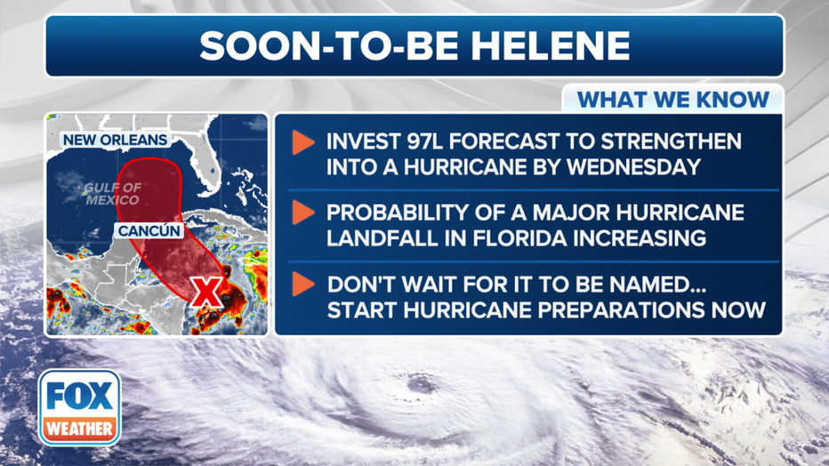
Millions of people living on the Gulf Coast from Louisiana to Florida are being urged to prepare as Invest 97L continues to become better organized and will likely become Tropical Storm or Hurricane Helene as the system enters the Gulf of Mexico in the coming days.
Millions of people from Louisiana to Florida are keeping their eyes on Potential Tropical Cyclone Nine, which was designated in the Caribbean Sea on Monday, and could wreak havoc on the U.S. Gulf Coast later this week.
JUMP TO: LOCATION l PROJECTED PATH l WHAT'S NEXT
A potential tropical cyclone designation permits the National Hurricane Center (NHC) to issue routine advisories on a system that has not yet developed into a tropical depression or tropical storm but brings a threat of 39-plus-mph winds to land within 48 hours.

Here's what the FOX Forecast Center knows about soon-to-be-Helene. (FOX Weather)
This falls within the time window of posting tropical storm and hurricane alerts, allowing the NHC to issue them with additional lead time and provide at-risk people with more advance notice of possible impacts in their area.
Where is Potential Tropical Cyclone 9?According to the latest advisory from the NHC, Potential Tropical Cyclone Nine is located about 130 miles south-southwest of Grand Cayman and 350 miles south-southeast of the western tip of Cuba.
This graphic shows the latest information about Potential Tropical Cyclone Nine. (FOX Weather)
As Potential Tropical Cyclone Nine gathers strength and heads toward the warm waters of the Gulf of Mexico, millions of people across the region have been told to prepare for potential impacts.
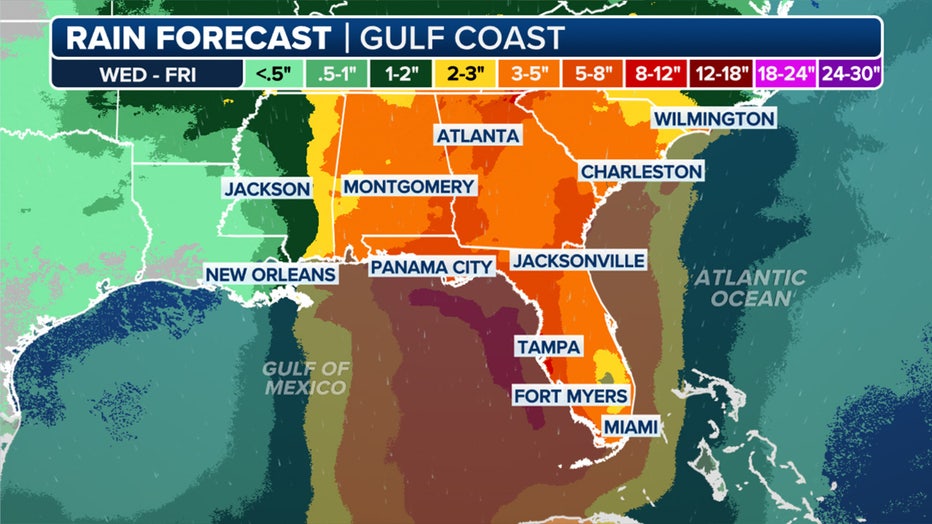
The NHC says there's the potential for a dangerous and life-threatening storm surge, heavy rain and strong winds to impact the Florida Panhandle and the west coast of Florida.
The rainfall forecast for the Southeast through Friday. (FOX Weather)
Potential Tropical Cyclone Nine has maximum sustained winds of 30 mph, and its moving off to the north at 6 mph.
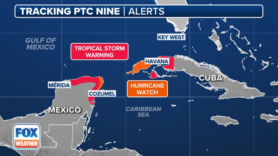
Where are watches and warnings in effect?Because of the threat that Potential Tropical Cyclone Nine has in the Caribbean and in the Gulf of Mexico, a Tropical Storm Warning was issued for Mexico's Yucata Peninsula from Rio Lagartos to Tulum, and a Hurricane Watch from Cabo Catoche to Tulum.
Current tropical alerts for Potential Tropical Cyclone Nine. (FOX Weather)
A Tropical Storm Warning was also issued for portions of Cuba for the Isle of Youth, Artemisa and Pinar del Rio. A Hurricane Watch is in effect for Pinar del Rio.
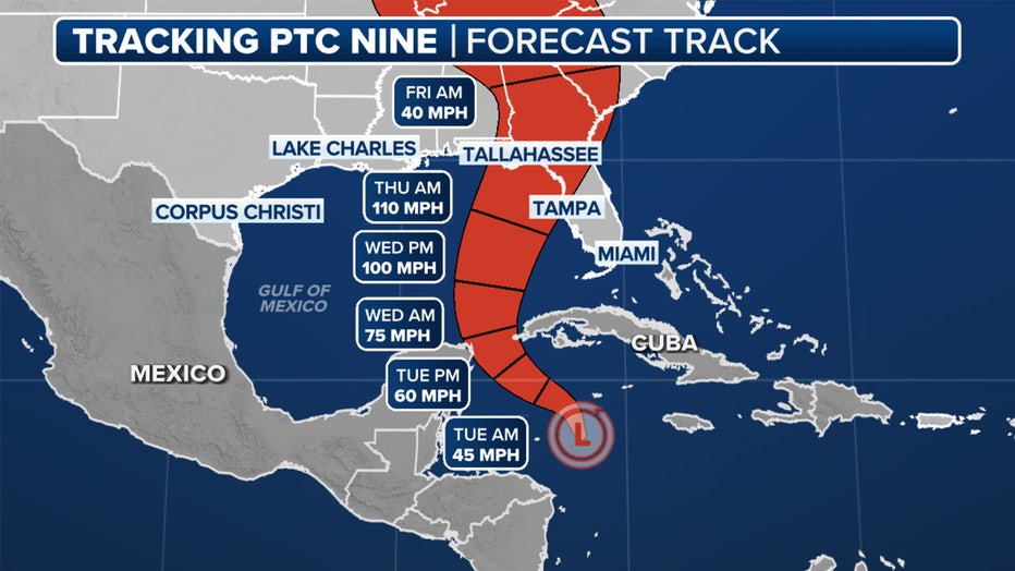
According to the NHC, Potential Tropical Cyclone Nine is expected to continue on a northwestward motion on Tuesday and Tuesday night, followed by a faster northward or north-northeastward motion on Wednesday and Thursday.
This graphic shows the potential track of Potential Tropical Cyclone Nine. (FOX Weather)
The NHC said the center of the system is forecast to move across the northwestern Caribbean Sea and into the southeastern Gulf of Mexico during the next couple of days.

Here are the spaghetti models for Potenital Tropical Cyclone Nine. (FOX Weather)
One area under watch is a tropical disturbance near the west coast of Africa, according to the NHC.
A look at the latest odds of development a tropical disturbance in the Atlantic. (FOX Weather)
The NHC says the disturbance is expected to continue moving westward over the next several days.
Environmental conditions could support some gradual development of the system, and a tropical depression could form during the middle to end of this week in the central or eastern tropical Atlantic.
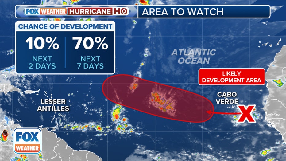
Right now, the NHC is giving the system a high chance of development.
NOAA Hurricane CenterFor more information, click HERE.
Steven Yablonski, with FOX Weather, helped contribute to this report.


