Francine becomes a hurricane, heads for Louisiana landfall
WWNO - New Orleans Public Radio
Published September 10, 2024 at 8:04 AM CDT
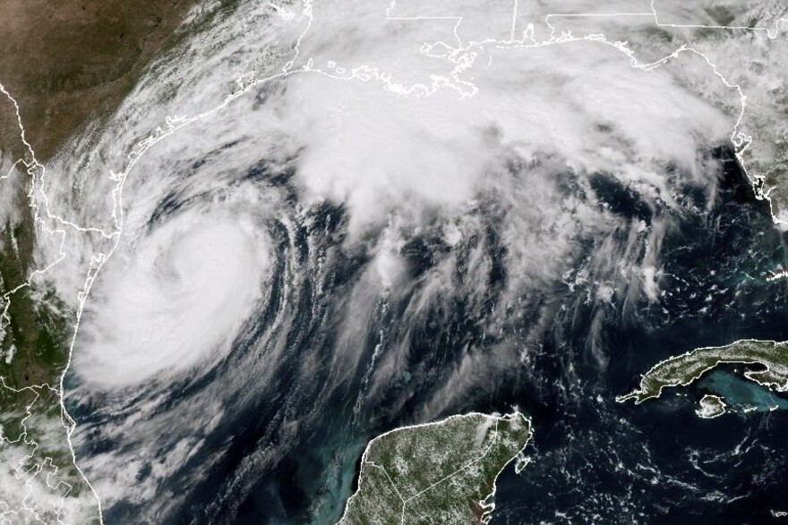
Francine strengthened into a hurricane Tuesday evening as the storm inched closer to the Louisiana coast.
The storm is forecast to make landfall in Louisiana sometime Wednesday as a Category 1 hurricane with 92 mph winds.
New Orleans was placed under a hurricane watch Tuesday afternoon, meaning hurricane conditions are possible within 48 hours.
At 7 p.m. CT Tuesday, Francine was centered about 350 miles southwest of Morgan City, Louisiana, packing maximum sustained winds of 75 mph. It was moving northeast at 10 mph.
AP

/
National Oceanic and Atmospheric Administration
The storm is forecast to move across the northwestern Gulf Tuesday evening, before it makes landfall in Louisiana sometime Wednesday or Wednesday night.
How could it impact Louisiana?It’s too soon to determine the exact timing and location of the storm’s landfall, but it's expected to bring potentially life-threatening storm surge and damaging winds to parts of Louisiana beginning Tuesday night.
National Oceanic and Atmospheric Administration
Southern Louisiana and other areas along the Gulf Coast could see up to 8 inches of rain into Thursday morning with some areas seeing isolated amounts of 12 inches, which could cause considerable flash and urban flooding.

National Oceanic and Atmospheric Administration
Forecasters said the storm surge could bring water between 3 to 10 feet above ground level in some parts.
Watches in effectA storm surge warning is in effect for:
Sabine Pass Texas to the Mississippi/Alabama BorderVermilion BayLake MaurepasLake PontchartrainA hurricane warning is in effect for:
The Louisiana coast from Cameron eastward to Grand IsleA storm surge watch is in effect for:
Mississippi/Alabama Border to the Alabama/Florida BorderMobile BayA hurricane watch is in effect for:
Lake Maurepas and Lake Pontchartrain, including metropolitan New OrleansA tropical storm warning is in effect for:
Texas and Louisiana coasts east of High Island to CameronEast of Grand Isle Louisiana to the Alabama/Florida borderLake Maurepas and Lake Pontchartrain, including metropolitan New Orleans Be preparedBe sure to monitor weather updates, and have a plan in place. Use this guide to help you and your family prepare.


